The Rise and Fall of Trade in the Port of Toronto
Reflections of a Modernizing Economy
Alex Laskewich
Toronto - 2023
The Port of Toronto, since its founding, was and still is based primarily around trade and increasing the economy of Toronto. Up until recent years the land around the harbour was used for industrial and commercial purposes but has slowly been replaced by residential buildings as the port becomes less vital to the economy of Toronto. In the early days of Toronto everything was centered around the port but with changes in commercial industries, the economic focal points of the city have changed. The primary focus will be on the 1960s and 1970s after the construction of the St. Lawrence Seaway. During those years we saw a boom in trade, but that fell off in later years as rapid modernization in that period exceeded what the port of Toronto was capable of.
Even before European settlers arrived in Canada, the Indigenous peoples used the site of Toronto as a link between Lake Ontario and Georgian Bay.1 In 1615, French explorers discovered the importance of this location as a trade passage and began using it as well. The early traders used canoes and eventually smaller transport ships to move supplies. If transportation methods had remained primitive and small, as used by early Indigenous peoples and Europeans, Toronto might still be a major trading hub today. During the Seven Years War the French withdrew from the area and in 1788 Lord Dorchester purchased the land that would become Toronto from the Mississauga Indians because of its useful location specifically regarding the fur trade.2 With the separation of Upper and Lower Canada, Lieutenant-Governor John Graves Simcoe chose Toronto as the provisional center for his administration because of its unparalleled harbour which would allow for easy defense of docked ships.3 As befits its important location as a trade hub, Toronto first became a city in 1834 and became the principal commercial market on the Canadian side of the Great Lakes.4
Not only is the history of the port important to the topic of the growth of the economy, but also the history of the Board of Trade, which helped establish the Harbour Commission which runs the port. The Board of Trade and the Harbour Commission were formed in 1845 and 1911 respectively.5 The Board of Trade's principle objectives have always been "to advance and render prosperous the lawful trade and commerce and to foster the economic and social welfare of the city of Toronto..."6 The Harbour Commission's role is to manage the operations and growth of the port and surrounding facilities. Both organizations originally had very close ties, but their respective operations have separated as they expanded. This close relationship in part stems from the similar goals of both organizations. The Board of Trade puts emphasis on the economy of Toronto and the port is essential to that economy.
Through the years, the Board of Trade and the Harbour Commission continued to work closely together. In 1975 the Board of Trade wrote a letter to the transportation minister which included several suggestions that they believed would improve how the Harbour Commission was run. The Board of Trade opened their suggestions by writing "The Board of Trade of Metropolitan Toronto has had a long standing and continuing involvement with the Toronto Harbour Commissioners, having been a principal contributor to the development of the role and structure of the Commissioners as it now exists."7 Their comments address details on the Board of Trade's relationship with the Harbour Commission. The Board recommends one of the members of the Commissioners, showing that they have the option to participate in the decision making of the leadership of the Port. The Board of Trade was a critical factor in the creation of the Harbour Commission. This was because they wanted a single entity to govern over the Toronto port since they felt that the economic potential of the port area was being neglected.8
Since its beginnings, the Harbour Commission was linked to trade and economic growth, and they used the land of the port area for this purpose. This relationship between the Board of Trade and the Harbour Commission is interesting because in their request for changes in how the commissioners operate, they require that more power be given to the federal government when running the commission. This was likely because at one point in the commission\'s history, there were more representatives from the city than other levels of government and they used their majority to force the commission into selling land to the city, therefore reducing the amount of land controlled by the Commission. Given that the request for changes was made in 1975, it is possible that the Board of Trade saw that the port was bringing in less commerce than in previous years and hoped that restructuring the leadership of the commission could help manage the losses from the decline in trade.
Not only did the Harbour Commission work with other municipal organizations, but they also worked closely with organizations on provincial, federal, and global levels. In his writing of the history of the Board of Trade, J. Castell Hopkins wrote that "There is no greater civilizer in the world than commerce. Prejudices are lessened; national animosities are minimized, and anything that will promote an increase of commerce between nations is to be hailed with gratification as tending to the welfare and mutual advantage of all concerned."9 This was certainly the case with the port of Toronto as changes were made to improve the port facilities and to increase trading levels and relationships among other cities in Canada and globally. This is especially evident when looking at the annual reports of the Harbour Commission which include information on which countries were making new ties with the Port of Toronto. For example, in 1971 the traffic section of the Harbour Commission was divided into its own entity from the Community Relations section.10 The traffic section of the Commission was responsible for making thousands of calls each year with current or potential clients who shipped to the port.
As the scope of international trade at Toronto increased, one big contributor to that increase was the construction of the St. Lawrence Seaway. On the topic of the changing metropolitan shorelines of cities along the Great Lakes, Mayer writes "The opening of the St. Lawrence Seaway has focused attention upon the need for improved port facilities, deeper and more accessible harbors, and additional shorefront lands for industrial development. But at the same time the expanding city and metropolitan populations require recreational facilities, including especially the use of the increasingly scarce shorelines."11 This could be the reason for both the rise and fall of trade in Toronto in the mid-20th century since the St. Lawrence seaway increased trade for Toronto at a time when more of the city was needed to expand the metropolitan area. The construction of the St Lawrence Seaway created an easy route for cargo ships to traverse making Toronto a hub for both domestic and international trade. However, with ever improving technologies, those involved in the shipping industry realized that larger cargo ships meant that more cargo could be transported at once and since the seaway was designed for ship sizes at the time of construction, trade began to wane, and Montreal began to take a bigger role as a trading port.
Although Toronto was certainly going to benefit from the newly built seaway, the project was much larger than one city. Canada and the United States wanted to increase the level of trade possible across the lakes between the neighbouring countries. The planning and construction of the St. Lawrence Seaway deserves attention itself. On this topic Ted Wickson writes, "The construction of the Seaway involved the labour of 15,700 men over a period of more than four years and cost in excess of \$470 million, of which Canada's share was about \$329 million."12 He also writes that the Seaway would make the port of Toronto accessible to 80 percent of global trade. This demonstrates that the Seaway was not meant to be a small project with minimal returns but something that was supposed to change the economic landscape not only in Toronto, but also for various other port cities in Canada and the United States. For a time, Toronto did show benefits from the seaway, as we can see in the Harbour Commission annual report from 1959 the year the Seaway opened. The report indicates that, overseas shipping amounted to 713, 186 tons which was an increase of 425, 418 tons from 1958 which was previously the highest tonnage of all time.13 That means that the construction of the Seaway more than doubled the previous record and proved its worth in the first year. In figure 1 we can see data from across twenty years at the port.14 Looking at the total tonnages shows a significant increase in tonnage around the time the Seaway was built and a steady decline throughout the late 1960s and early 1970s.15
| Year | Number of regular liner services serving the port | Total number of arrivals and departures of ships | Total cargo tonnage |
|---|---|---|---|
| 1956 | 20 | 910 | 164, 929 |
| 1957 | 24 | 1046 | 200, 395 |
| 1958 | 28 | 1317 | 287, 768 |
| 1959 | 40 | 1724 | 713, 186 |
(First year new St. Lawrence Seaway)
| 1966 | 56 | 2288 | 1, 462, 245 |
| 1967 | 56 | 2374 | 1, 497, 187 |
| 1968 | 41 | 1788 | 1, 393, 763 |
| 1969 | 44 | 1862 | 1, 644, 529 |
| 1970 | 37 | 1474 | 1, 282, 237 |
| 1971 | 42 | 1324 | 1, 250, 540 |
| 1972 | 37 | 1236 | 1, 715, 263 |
| 1973 | 27 | 758 | 1, 076, 473 |
| 1974 | 25 | 558 | 900, 016 |
| 1975 | 25 | 607 | 1, 020, 685 |
| 1976 | 24 | 678 | 1, 033, 666 |
Figure 1: Transcribed chart showing data on the Port of Toronto from 1959-1976.
Although the St. Lawrence Seaway contributed to changes at the Port of Toronto, it was a project on a much larger scale than one city. A project that would focus on improving the port facilities in Toronto specifically was the Bold Plan. The Bold Plan, including the outer harbour, was intended to expand the area around the port and artificially increase the amount of space available for commercial use. Figure 2 illustrates the proposed map of the port if the Bold Plan was completed.16 Expansions would be made to the airport (brown) and commercial area (blue), as well as more open space (green) and housing on the waterfront (yellow).17 This plan was of course made at a time when the scope of trade and therefore the space needed in the port was dwindling. The completion of the Outer Harbour never happened because the extra space was never ultimately needed as trade slowly fell off later in the 20th century (see figure 3).18


A part of the Bold Plan was to expand the Island Airport to increase its capacity and effectiveness. The Billy Bishop or Island airport, was since its founding meant to be the primary airport in Toronto, meaning that travel by both air and sea would be centered around the port area making it a perfect trading hub (see figure 4).19 At one point the Island Airport was even the busiest airport in Canada.20 As reported in the 1971 annual report from the Toronto Harbour Commission, the airport was at the time often referred to as the "gateway to Ontario and Canada for general aviation aircraft."21 The Island airport moving to the sidelines was a decision partly influenced by the Board of Trade. With planes becoming larger and noisier and both commercial and personal flights increasing, the department of transportation put forth a plan to expand the Malton airport to accommodate the future needs of air travel.22 Although the Malton expansion did not happen, the Island airport fell out of favour and was designated by the board to be used for private and inter-city flights, as they have smaller planes that fit on the runway. The use of new airports was again a loss of trade for the port area since freight flown by air would now be moving elsewhere rather than Island airport which was originally intended.

A good example of the changing focus of the port area is the location of the port archives themselves. Relocated to the pier 52 warehouse that, alongside it's neighbouring pier 51 warehouse were at one point used for storing materials for trade but have now been purchased and will be converted into movie studios (see figure 5).23 Illustrating that although the port is moving away from its role as a major trading hub, it still has an important role in the economy of the city. Around that area, the outer harbour, which was originally intended to be used for extra warehouses and port industrial space has been converted into a blue flag beach, a dog park, and a little further off is the marina. Much of what used to be dock space has also recently been undergoing the transition to high-rises and other forms of urban living. However even with the living space in Toronto expanding to the harbour, commercial activities are still active with mixed buildings containing both office space and living space being a popular design with architects. Even with these changes however, trade continues to expand in some areas of the port.

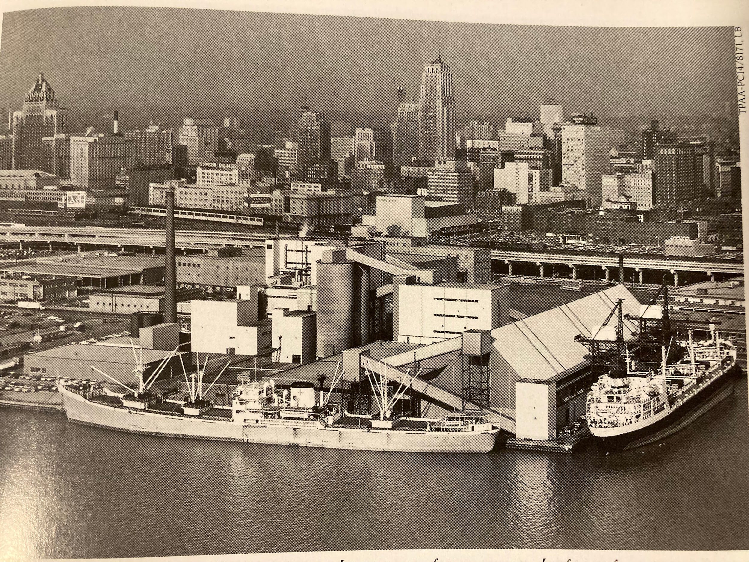
In addressing the post war changes, we can see that the Port of Toronto would not exist in the form that it is today without trade being the main purpose throughout its history (see figure 6).24 Trade is becoming less important to the port area as it becomes more residential while other businesses are taking over. Although Toronto tried to keep up with the modern world, the rapid improvement of shipping technologies is likely the only reason that the port is not still a central trading hub. With planes becoming too large for the island airport and some transport ships becoming too large for the St. Lawrence Seaway, the original plans for the port had to change. Even though trade may have taken a downturn shortly before the 21st century, it was still instrumental in the creation of the port and continued use and development through the years.
Acknowledgements
I thank Michael Moir and Jeff Hubbell for providing aid in locating sources and sharing their experiences about the Harbour Commission.
-
Ted Wickson, Reflections of Toronto Harbour: 200 Years of Port Development and Activity (Toronto, Ontario: Toronto Port Authority, 2002), 17. ↩
-
Geoffrey H Stanford, To Serve the Community: The Story of Toronto's Board of Trade (Toronto, Ontario: University of Toronto Press, 1974), 1. ↩
-
Stanford, To Serve the Community, 2. ↩
-
Margaret Beattie Bogue, “Patterns of Growth through 1872,” in Fishing the Great Lakes: An Environmental History, 1783–1933 (University of Wisconsin Press, 2001), 28-43, 33. ↩
-
“Home,” Toronto Region Board of Trade. https://bot.com/home; Wickson, Reflections of Toronto Harbour, 8. ↩
-
Stanford, To Serve the Community, 7. ↩
-
The Board of Trade of Metropolitan Toronto (Toronto, n.d.). ↩
-
Roy Merrens, “Port Authorities as Urban Land Developers: The Case of the Toronto Harbour Commissioners and Their Outer Harbour Project, 1912-68 – Urban History Review / Revue D'histoire Urbaine,” Érudit (Urban History Review / Revue d'histoire urbaine, August 6, 2013), https://www.erudit.org/fr/revues/uhr/1988-v17-n2-uhr0759/1017654ar/. ↩
-
J. Castell Hopkins, The Toronto Board of Trade: “A Souvenir:” History of the Queen City and Its Board of Trade, with Biographical Sketches of the Principal Members Thereof (Toronto, Ontario: Sabiston Lithographic & Publishing co, 1893), 115. ↩
-
The Toronto Harbour Commissioners (Toronto, n.d.). ↩
-
Harold M Mayer, “Metropolitan Shorelines of the Great Lakes,” in Canadian Geographer (John Wiley & Sons, Ltd, 2008), 197-202. ↩
-
Stanford, To Serve the Community, 241. ↩
-
The Toronto Harbour Commissioners (Toronto, n.d.). ↩
-
Figure 1: Transcribed chart showing data on the Port of Toronto from 1959-1976. The Toronto Harbour Commissioners, Figure 1, photograph (Toronto, n.d.). ↩
-
The Toronto Harbour Commissioners (Toronto, n.d.). ↩
-
Figure 2: 1968 map of the proposed changes being made under the Bold Plan. Ted Wickson, Reflections of Toronto Harbour: 200 Years of Port Development and Activity, Reflections of Toronto Harbour: 200 Years of Port Development and Activity (Toronto, Ontario: Toronto Port Authority, 2002), 101. ↩
-
Wickson, Reflections of Toronto Harbour, 101. ↩
-
Figure 3: Port of Toronto after 12 years of lakefilling in 1971, future Outer Harbour is on the left. Ted Wickson, Figure 3, photograph (Toronto, n.d.), 77. ↩
-
Figure 4: The Toronto Island airport in 1961. Ted Wickson, Figure 4, photograph (Toronto, n.d.), 123. ↩
-
Wickson, Reflections of Toronto Harbour, 123. ↩
-
The Toronto Harbour Commissioners (Toronto, n.d.), 6. ↩
-
Stanford, To Serve the Community, 245. ↩
-
Figure 5: Piers 51 (left) and 52 (right) in 1976 when both were being used for trade purposes. Ted Wickson, Figure 5, photograph (Toronto, n.d.), 107. ↩
-
Figure 6: Cargo freighters docked at the Redpath Sugar refinery in 1964. Ted Wickson, Figure 6, photograph (Toronto, n.d.), 75. ↩