All Rivers Lead to Home:
How the Carrying Place Built Toronto
Bram Fookes
Toronto - 2023
Before paved roads were carved into the rugged forests of Southern Ontario, water routes were the easiest way to traverse the harsh landscape. As such, the site of modern-day Toronto has always been inextricably linked to water. Long before any city stood at the mouth of the Humber River on Lake Ontario, the epicentre of today's metropolis still bustled with activity. To Indigenous peoples, the site was called 'Tkaronto,' meaning "trees in the water," a reference to the local practice of placing multitudes of wooden stakes in the river to corral its rich stocks of fish into nets.1 Trails were carved along the Humber's shoreline by millennia of foot traffic as Indigenous peoples travelled to the river's mouth year after year to take advantage of the rich food source it provided. These footpaths along the shores of the Humber grew to eventually bridge the entire distance between Lake Ontario and Georgian Bay via Lake Simcoe. This route would come to be known as the "Carrying Place" by the Indigenous people who relied on it for quick travel across their homeland of Southern Ontario (Figure 1).2

This exploration of the Carrying Place demonstrates its multifaceted importance to Indigenous peoples in addition to the French, who were the first Europeans to use it. The Carrying Place was a critical artery in the human landscape of Southern Ontario from the seventeenth to the mid-eighteenth centuries. Through an examination of primary and secondary sources, the fact that the origins of Toronto as a city lie in the critical water route of the Carrying Place portage are brought into sharp focus. This route shaped trade networks and transportation methods, which in turn shaped the politics, diplomacy, and social relations of those who relied upon it. This fact holds true not only for the Indigenous peoples of the area, but also for the Europeans that those first inhabitants taught to use the trail.
To contextualize the critical importance of the Carrying Place to the development of modern-day Toronto, the importance of water travel to Ontario's earliest inhabitants and explorers must be made clear. Rivers served as roads, easily traversed by light and versatile birchbark canoes to bypass brutal marches through the thick forests of the interior.3 Long before the arrival of Europeans in what would become Upper Canada, Southern Ontario
was situated amid a vast North American trade network stretching from the western shore of Lake Superior to encompass the entirety of the Great Lakes.4 Rivers, and footpaths along their shores, allowed this trade to be incredibly versatile, and Indigenous travellers devised several shortcuts to avoid being limited by the layout of the lakes alone. The light weight and shallow draft of Indigenous canoes allowed their pilots to exploit the transportation potential of rivers to their fullest extent. Indigenous navigators could follow a river until their canoes scraped the riverbed, then carry the craft -- and whatever goods they were transporting -- overland to the next water route using well-worn trails -- a practice known today as "portaging."5
The goods that these early traders carried were diverse -- large quantities of foodstuffs, especially cornmeal, were often transported along the riverine arteries of Southern Ontario.6 Diverse forms of clay pottery, as well as beads and jewellery made of either stone or shells were also traded along these ancient highways, contributing to the centuries-long exchange of artistic goods and ideas that thrived in the Great Lakes region prior to European contact.7 Goods made of flint and chert from as far south as the Niagara Peninsula found their way to what is today northern Simcoe County incredibly early in the archaeological record, demonstrating that Indigenous peoples had been harnessing the waters of Southern Ontario for their own purposes millennia before the arrival of Europeans.8
Among the most important of these early trade routes was the route known today as the Toronto Carrying Place. This portage route stretched roughly northward from the mouth of the Humber River at the northwestern shore of Lake Ontario in present-day Etobicoke. It then followed the banks of the Humber inland until it reached Lake Simcoe, and from there it was only a short trip to Georgian Bay.9 The "Carrying Place" technically refers to two closely linked routes -- one following the Humber valley, and one roughly following the Rouge River to the east.10 Few records exist describing the specifics of the eastern route, but it served the same purpose as the western route: linking Lake Ontario to Georgian Bay. Thanks to these well-worn trails, travellers did not need to brave the thick forests that laid between these two critical bodies of water. Evidence even exists which points to the idea that those who used this trail did not need to carry their canoes the entire length of the portage -- some 120 kilometres. Instead, it was likely common for travellers to leave their canoes at the entrance to the portage and construct new ones at their destination - abundant birch bark in the region provided a near endless supply of new canoes for skilled artisans.11
By providing transport between two major bodies of water, the Carrying Place also necessarily linked different groups of people. In the precolonial period, several Indigenous groups were linked by this route. Primary among these were the Wendat (Huron) people, whose home territory sat between the southeastern shore of Georgian Bay and Lake Simcoe.12 The Wendat people used the Carrying Place route to travel between their homeland and the rich hunting grounds on the northern shore of Lake Ontario.13 Roughly opposite the entrance to the Carrying Place across Lake Ontario on the Niagara Peninsula was the territory of the people known to modern scholars as the 'Neutrals.' It is unknown what name the people of the Niagara region used to refer to themselves, but they were known to the Wendat as "Attawandaron."14 Their lands were linked to those of the Huron by trails including a section of the Carrying Place.15 To the east of the Neutrals on the southern shore of Lake Ontario were the lands of the Haudenosaunee, a confederation of five (later six) nations who cooperated in matters of diplomacy and warfare.16 The Haudenosaunee often skirmished with the Wendat, while the Neutrals remained aloof from conflicts between these two stronger groups -- thus earning the moniker "Neutral" when Europeans later observed this state of affairs.17
This was the status of the Carrying Place in the centuries preceding the arrival of Europeans in Southern Ontario. The Carrying Place trail was relied upon by the Wendat as a route to the rich hunting grounds of the Lake Ontario shoreline, but it also posed a danger as an open back door to vulnerable Wendat villages for the Haudenosaunee.18 The liveliness of Southern Ontario's precolonial political landscape would have been greatly diminished without the Carrying Place providing quick and reliable overland transportation to the vital resource of Lake Ontario's rich fishing and hunting grounds.
The Carrying Place trail served to link the two bodies of water most important to the Wendat people: Georgian Bay and Lake Ontario. From their villages on the Georgian Bay shoreline, Wendat hunters travelled the Carrying Place every summer in order to hunt and fish along the temperate northern shoreline of Lake Ontario.19 Glenn Turner envisioned the trail as a critical "road home" for the Wendat -- an easy road and a place of sanctuary to be followed back to safety after months spent hunting in the wilderness. 20 In addition, these portage routes aided the Wendat -- who were also prolific traders -- in transporting goods between villages dotting the rivers and shorelines of Southern Ontario.21 The Wendat people effectively monopolized trade between peoples to their north and south through controlling important trade routes, including the Toronto Carrying Place.22 Northern peoples who often relied upon agricultural products like corn from highly agricultural groups such as the Haudenosaunee and Neutrals were at the mercy of Wendat traders. This is because traders from the southern side of Lake Ontario were forced to rely on the Wendat as middlemen, due to their control over the Carrying Place.23 The Humber River region in the precolonial period can be envisioned as a cross between a major modern highway and the Eurasian silk road. Wendat travellers easily traversed the thick forests that divided the rolling fields of their homeland from the rich hunting and fishing grounds of Lake Ontario's northern shoreline.
Control over the Carrying Place did not only benefit the Wendat internally. It also allowed them to dictate relations and trade between peoples to their north and south. By controlling this vital route, the Wendat were also able to use it to conduct trade with their neighbours. By selling surpluses of game and corn which existed largely because they controlled this critical route of transport and trade, the Wendat participated in a self-strengthening cycle centered around major rivers and portage routes.
Over the course of the seventeenth century, Wendat supremacy over routes of trade and transport would crumble for several reasons. The arrival of Europeans on the eastern seaboard during the latter part of the previous century had opened larger trade markets, especially for furs. The Wendat were the traditional rivals of the Haudenosaunee confederation on the southern shore of Lake Ontario. Low-intensity conflict between the two groups had existed for generations, but tensions were inflamed further after the Wendat made a trading alliance with the newly arrived French.24 The Haudenosaunee, eager to grow their own political and economic power in the region, began making moves northward across Lake Ontario, using the Carrying Place to control the rich hunting grounds there.
European diseases, which often travelled faster than individuals, arrived in the Wendat's territory just before the Haudenosaunee intensified their attacks.25 Epidemics of new diseases such as smallpox, measles and whooping cough swept through eastern North America, decimating Indigenous peoples indiscriminately -- Trigger estimates that the Wendat population dropped by fifty percent over the course of only six years in the opening decades of the seventeenth century.26 The Haudenosaunee were hit similarly hard by these epidemics, and a dramatic decline in population coincided with a series of devastating military campaigns into Southern Ontario.27 A Jesuit who lived amongst the Wendat between 1643 and 1644 wrote of this period: "The scourge of war [...] has continued to such an extent, for a year past, that one may say that this country is but one scene of massacre."28 For the Haudenosaunee, these wars also served the dual purpose of replenishing their numbers -- the Haudenosaunee would often adopt those captured in war.29 Thus, the Carrying Place became a highway of war, as it carried Haudenosaunee warriors into Wendat lands where they nearly annihilated the Wendat as a tribe.30 This destruction of the Wendat, however, nevertheless allowed the Haudenosaunee to use the Carrying Place's resources to survive as a tribe in the face of devastating losses. Those Wendat who were not captured or killed fled to French-controlled territories, and most modern understandings of this time period rely heavily on French sources.
The first French explorers and missionaries to arrive in Southern Ontario at the turn of the seventeenth century relied on Indigenous guides to show them the best routes across the rugged terrain. The first Jesuits to reach Wendat territory were ferried to Georgian Bay from Quebec via the Ottawa river by Wendat traders in 1634.31 From there, trade and dialogue with the Wendat introduced use of the Carrying Place to these new arrivals, and its value was quickly demonstrated to the Jesuits. The Jesuit Relation of 1637 relates the story of a lone Jesuit who fell sick and could no longer carry his cargo on foot. He was found by a party of Wendat, who took him by canoe along the Humber River back to his mission, where he was nursed back to health.32 Early encounters such as this one quickly drove home the importance of the Carrying Place for French visitors to the region, who would use them extensively during their time in Ontario.
The French strategy for Southern Ontario was to make alliances with local tribes, especially the Wendat, to secure trading partners and allies to make up for the low number of French settlers in the region.33 Most French influence in the farther regions of Southern Ontario, especially the north shore of Lake Ontario and into Wendat territory, was expressed through attempts to Christianise the local Indigenous peoples.34 The rationale for the push to Christianize the region was multifaceted. A common religion would facilitate smooth trading relations, and settlements jointly founded by French missionaries and converted Indigenous people were seen as the first step towards imposing a 'European' way of life on the region.35
Water travel and portage routes were essential for facilitating this spiritual push, demonstrating that the Carrying Place's importance extended to the social, in addition to the economic and political realms. In this way, the Carrying Place demonstrated its function as a network for the facilitation of change. Routes including the Carrying Place were used in this period both by fur traders carrying goods between the French and Indigenous peoples in addition to missionaries carrying ideas between the two.36 A later painting by George Agnew Reid (figure 2) illustrates the enduring memory of the Carrying Place as an important trade route in both Indigenous, and early colonial, Ontario.37

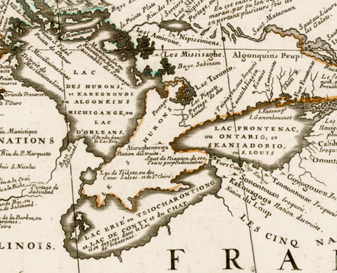
Early maps of Southern Ontario by Jesuit explorer-missionaries highlighted the importance of these portage routes, especially the Carrying Place. A map created by Jesuits Louis Jolliet and Jean-Baptiste Franquelin in 1675 demonstrates this well. Much of the Great Lakes coastline and inland regions are nebulously accurate at best, but Lake Simcoe is accurately situated, as is the route of the Carrying Place trail.38 Vincenzo Coronelli's 1688 map (Figure 3) shows the continuing importance of this trail to both explorers and missionaries.39 This map is once again missing some important geographic features -- most notably nearly completely omitting the Bruce Peninsula. However, the Carrying Place is still marked in great detail, extending from the northern shore of Lake Ontario to Lake Simcoe, labelled "Portage de dix Lieues" or 'portage of ten leagues.'40 The careful attention paid to accurately marking out the Carrying Place at the expense of other geographical features demonstrates that this route was one of the most important features about the Lake Ontario shoreline to early European explorers. The 'portage of ten leagues' was critical to the development of French-Wendat relations. Each party learned something from the other thanks to the easy communication afforded by river transport. As Turner notes, seventeenth century Wendat history and culture is much better understood by Western scholars than those of neighbouring Indigenous groups.41 This is because of the ease of travel which the Carrying Place afforded to Jesuit missionaries once they began using it to penetrate the interior of Southern Ontario.
The southern part of the Carrying Place was home to a few Haudenosaunee villages after the expulsion of the Wendat, and knowledge of these can also be traced to accounts from Jesuits who travelled along the Carrying Place.42 The Jesuits even reached the Neutral Nation of the Niagara Peninsula via this route, relying on the relatively easy journey to reach these people who were considered quite remote to Europeans.43 The thorough record keeping of the Jesuit order helps to illustrate the social landscape that encompassed the Toronto Carrying Place throughout the seventeenth century. In that period, the trail facilitated the spread of war and disease, but also a grand cultural exchange which would permanently affect both the Indigenous peoples of the region and newly arrived Europeans. The French colonial policy of trade, evangelization and alliance was greatly aided by portage routes such as the Carrying Place.
In the following century, the French would lose control of North America to the British as a result of the Seven Years' War (1756 -- 1763), which saw Great Britain wrest control of Canada from France.44 The British relied far more heavily on a policy of land purchase and settlement by Europeans in their Canadian territories, especially after the conclusion of the American Revolutionary War in 1783 forced Britain to look for somewhere to settle loyalist populations.45 The British government focused their land purchases around the most important communication route in the region, which directly followed the course of the Carrying Place (Figure 4), reinforcing the fact that use of this ancient highway was critical for any group that sought to control Southern Ontario.46 The British town of York, later to become Toronto, was initially clustered at the mouth of the Humber in order to directly control one terminus of the Carrying Place.47

The Toronto Carrying Place proved critical to the economic, political, social and spiritual landscapes of Southern Ontario long before European-style roads crisscrossed the region. Due to the existence of an easily traversable route linking major bodies of water upon which Indigenous peoples relied for food and trade, precolonial Southern Ontario was a vibrant and interconnected place. People had a convenient means by which to travel between Georgian Bay and Lake Ontario without having to canoe around the shorelines of the Great Lakes themselves. Thanks to this major portage route providing an easy route to those first Jesuit explorers to reach the Indigenous peoples of Ontario's interior, historians have a wealth of written sources about these first peoples. Toronto owes its existence to the Carrying Place trail. The city could not have been founded anywhere -- it grew up around the rich lands and waters at the mouth of the Humber, and it came with a built-in way to reach inland areas of Southern Ontario. The importance of the Toronto Carrying Place has been recognized as such by every group who has controlled it since the land was first settled, from Indigenous peoples, to the French, to the British, to modern Canadians.
-
Allan Levine, "The Carrying Place," in Toronto: Biography of a City, (Madeira Park: Douglas & McIntyre, 2014): 28; Glenn Turner, The Toronto Carrying-Place: Rediscovering Toronto's Most Ancient Trail, (Toronto: Dundurn, 2015): 39. ↩
-
Figure 1: A map depicting the route of the Carrying Place. Toronto can be seen at the bottom. Konstantin Manukyan, "The Humber and its Currents: Informing Public Place Through Historical Analysis," (Laurentian University, 2022): 60. ↩
-
Bruce G. Trigger, The Children of Ataensic: A History of the Huron People to 1660. (Kingston: McGill-Queen's University Press, 1987): 44. ↩
-
William A. Fox, "The Odawa." In The Archaeology of Southern Ontario to A.D. 1650, eds., Chris J. Ellis & Neal Ferris.
(London: Ontario Archaeological Society, 1990): 465. ↩
-
Trigger, The Children of Ataensic, 165 -- 166. ↩
-
Trigger, The Children of Ataensic, 63. ↩
-
Trigger, The Children of Ataensic, 62 -- 63. ↩
-
Trigger, The Children of Ataensic, 168. ↩
-
Turner, The Toronto Carrying Place, 46. ↩
-
Turner, The Carrying Place, 48. ↩
-
Turner, The Carrying Place, 20. ↩
-
Trigger, The Children of Ataensic, 27 -- 29. ↩
-
Turner, The Carrying Place, 30. ↩
-
Turner, The Carrying Place, 45. ↩
-
Trigger, The Children of Ataensic, 32. ↩
-
Turner, The Carrying Place, 45 -- 46. ↩
-
Turner, The Carrying Place, 45. ↩
-
Turner, The Carrying Place, 46. ↩
-
Turner, The Carrying Place, 30. ↩
-
Turner, The Carrying Place, 30. ↩
-
Turner, The Carrying Place, 30 -- 32. ↩
-
Trigger, The Children of Ataensic, 166. ↩
-
Trigger, The Children of Ataensic, 166. ↩
-
Turner, The Carrying Place, 50. ↩
-
Trigger, The Children of Ataensic, 499. ↩
-
Trigger, The Children of Ataensic, 499. ↩
-
Daniel P. Barr, Unconquered: The Iroquois League at War in Colonial America, (Westport: Praeger, 2006): 37. ↩
-
Rueben Gold Thwaites, ed. The Jesuit Relations and Allied Documents. Vol. 26. (Cleveland: The Burroughs Brothers Company, 1898): 175. https://archive.org/details/jesuits26jesuuoft ↩
-
Barr, Unconquered, 40. ↩
-
For a more comprehensive discussion of the Wendat-Haudenosaunee wars, see Trigger, The Children of Ataensic, 751 -- 788. ↩
-
Thwaites, The Jesuit Relations Vol. 7, 219 -- 223. ↩
-
Thwaites, The Jesuit Relations Vol. 13, 93. ↩
-
Trigger, The Children of Ataensic, 228 -- 229. ↩
-
Trigger, The Children of Ataensic, 287. ↩
-
Trigger, The Children of Ataensic, 287. ↩
-
Trigger, The Children of Ataensic, 290. ↩
-
Figure 2: Reid's painting of how traders would use the Carrying Place to transport goods. George Agnew Reid, The Short Portage -- The Carrying Place, La Salle on the Way over the Humber River to the Holland River and on to Lake Simcoe. Archives of Ontario. http://www.archives.gov.on.ca/en/explore/online/franco_ontarian/trade.aspx ↩
-
Carl Kupfer and David Buisseret, "Seventeenth-Century Jesuit Explorers' Maps of the Great Lakes and Their Influence on Subsequent Cartography of the Region," in Journal of Jesuit Studies 6 (2019), 67. https://doi.org/10.1163/22141332-00601005 ↩
-
Figure 3: Vincenzo Coronelli's 1688 map marks the Carrying Place (circled in red) just above Lake Ontario -- called "Lac Frontenac ou Ontario" in this image. Vincenzo Coronelli, "Partie Occidentale Du Canada Ou De La Nouvelle France Ou Sont Les Nations Des Ilinois, De Tracy, Les Iroquois, Et Plusiers Autres Peoples, Avec La Louisiane Nouvellement Decouverte Etc." 1688. Map. Bibliotheque Et Archives Nationales Due Quebec. ↩
-
Coronelli, "Partie Occidentale Du Canada." Map. ↩
-
Turner, The Carrying Place, 32. ↩
-
Thwaites, The Jesuit Relations Vol. 28, 12. https://ia600206.us.archive.org/8/items/jesuits28jesuuoft/jesuits28jesuuoft.pdf ↩
-
Trigger, The Children of Ataensic, 688 -- 689. ↩
-
William Kingsford, The History of Canada. Vol. 4. (Toronto: Rowsell & Hutchison, 1890): 500 -- 503. ↩
-
Gwen Reimer, "British-Canada's Land Purchases, 1783 -- 1788: A Strategic Perspective," in Ontario History 111 (Spring 2019): 36. https://doi.org/10.7202/1059965ar ↩
-
Figure 4: Gwen Reimer's map depicting Britain's land purchasing strategy to cement strong lines of transport and communication in Upper Canada. Note the purchases that follow the Carrying Place trail. Reimer, "Land Purchases," 38. ↩
-
Reimer, "Land Purchases," 38. ↩